Litho-structural study and depth estimation of Shaki area of Southwestern, Nigeria using high resolution aeromagnetic data
Keywords:
Earthquake, Fault, High resolution aeromagnetic data, Euler deconvolution, ShakiAbstract
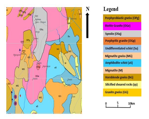
Little studies have been carried out in the investigation of some geological faults associated with seismic activities in Nigeria; probably due to the fact that Nigeria is believed to be sitting on a seismically safe African plate. However, the nation has experienced series of tremors in the last few decades. Hence, there is a need to investigate the lithological structural trends in some parts of Southwestern Nigeria to determine the tectonic stability of the study area. This research therefore investigates the litho-structural trends and the overburden thickness around Shaki area, Southwestern, Nigeria. High resolution aeromagnetic data (HRAD) of Shaki (sheet 199) was obtained from the Nigeria Geological Survey Agency; it was processed, enhanced, and interpreted using Geosoft Oasis Montaj 6.4.2 data processing and analysis software package. The depth to basement analysis were done using Euler Deconvolution (ED), Radially Average Power Spectrum (RAPS) and Source Parameter Imaging (SPI) to evaluate the depth to basement of the investigated area. Results of the estimated depth to basement obtained from ED, RAPS and SPI revealed 136-6155 m, 0.2-0.65 m, 96-3229 m. Thus, based on the results obtained from the investigated area, the basement of the area is relatively shallow compared to sedimentary basement area. In conclusion, the faults in the area are responsible for the earth tremor experienced around Shaki in August 2021. Thus, the area could be further probed using seismic refraction method.
Published
How to Cite
Issue
Section
Copyright (c) 2025 O. M Adedokun, O. P. Oladejo, K. O. Suleiman, K. N. Alao, E. O Adeniyi, H. Otobrise, O. Adedokun, L. A. Sunmonu

This work is licensed under a Creative Commons Attribution 4.0 International License.