Groundwater potential assessment using integrated multidisciplinary techniques in Shadadi, central Nigeria
Keywords:
Groundwater potential, Analytic hierarchy process, Vertical electrical sounding, ShadadiAbstract
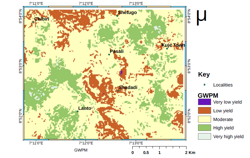
Rising demand for potable water, rapid urban expansion, industrialization, and the essential role of water in human existence have increased pressure on groundwater resources. In Shadadi, central Nigeria, this pressure is compounded by numerous unproductive boreholes. This study integrated geographic information systems (GIS), remote sensing (RS), geological mapping, and geophysical techniques to account for geomorphological features and subsurface architecture. Seven thematic parameters were superimposed in GIS to develop a groundwater potential map (GWPM), and each criterion and subclass was evaluated, weighted, and normalized using the analytic hierarchy process (AHP). Interpreted vertical electrical sounding (VES) and geoelectric-section results, constrained by lithologic logs, delineated topsoil, sandy clay, weathered basement, fractured basement, and fresh basement layers. Aquifers occur within the weathered and fractured basement zones. Aquifer depth varies regionally, from less than 15 m in northern and western areas to more than 60 m in southern and northeastern sectors. The AHP-derived GWPM was classified into very high, high, moderate, low, and very low zones, representing 0.7%, 23.8%, 60.5%, 14.9%, and 0.1% of the study area, respectively. Validation using 49 drilled boreholes supported the reliability of the GWPM; Cohen's kappa was 0.78, indicating substantial agreement between observed and projected yield classes.
References
[1] World Economic Forum, The Global Risks Report 2020, 15th ed., World Economic Forum, Geneva, Switzerland, 2020. Available online: https://www.weforum.org/publications/the-global-risks-report-2020/.
[2] H. Djuma, A. Bruggeman, M. Eliades & M. A. Lange, ``Non-conventional water resources research in semi-arid countries of the Middle East'', Desalination and Water Treatment 57 (2016) 2290. https://doi.org/10.1080/19443994.2014.984930. DOI: https://doi.org/10.1080/19443994.2014.984930
[3] J. C. Egbueri, C. N. Mgbenu & C. N. Chukwu, ``Investigating the hydrogeochemical processes and quality of water resources in Ojoto and environs using integrated classical methods'', Modeling Earth Systems and Environments 5 (2019) 1443. https://doi.org/10.1007/s40808-019-00613-y. DOI: https://doi.org/10.1007/s40808-019-00613-y
[4] A. A. Akinlalu, A. Adegbuyiro, K. A. Adiat, B. E. Akeredolu & W. Y. Lateef, ``Application of multicriteria decision analysis in prediction of groundwater resources potential: A case of Oke-Ana, Ilesa area, southwestern Nigeria'', NRIAG Journal of Astronomy and Geophysics 6 (2017) 184. https://doi.org/10.1016/j.nrjag.2017.03.001. DOI: https://doi.org/10.1016/j.nrjag.2017.03.001
[5] S. Maurya, R. M. Pradhan & A. Singh, ``Characterization of structurally complex granitic basement rocks using multi-geophysical data: Insights into subsurface weathered bedrock zones and groundwater exploration'', Near Surface Geophysics 23 (2025) 324. https://doi.org/10.1002/nsg.70007. DOI: https://doi.org/10.1002/nsg.70007
[6] N. G. Goki, F. X. O. Ugodulunwa, J. K. Ogunmola, I. A. Oha & J. O. Ogbole, ``Geological controls for groundwater distribution in the basement rocks of Kanke, central Nigeria from geophysical and remotely sensed data'', African Journal of Basic and Applied Science 2 (2010) 104. Available online: https://idosi.org/ajbas/ajbas2(3-4)10/8.pdf. DOI: https://doi.org/10.3923/ojesci.2010.89.94
[7] M. P. Billings, Structural Geology, 3rd ed., Prentice-Hall of India, New Delhi, India, 1972, pp. 419--429. https://www.scribd.com/document/592560439/M-P-Billings-Structural-Geology-3rd-Edition.
[8] O. K. Olomo, O. A. Danga & A. O. Aliyu, ``Exploration of quality groundwater through lineament delineation in Okene and its surroundings'', Geosystems and Geoenvironment 4 (2025) 100350. https://doi.org/10.1016/j.geogeo.2024.100350. DOI: https://doi.org/10.1016/j.geogeo.2024.100350
[9] M. Morelli & F. Piana, ``Comparison between remotely sensed lineaments and geological structures in intensively cultivated hills (Monferrato and Langhe domains, NW Italy)'', International Journal of Remote Sensing 27 (2006) 4471. https://doi.org/10.1080/01431160600784200. DOI: https://doi.org/10.1080/01431160600784200
[10] A. I. Olayinka, ``Geophysical siting of boreholes in crystalline basement areas of Africa'', Journal of African Earth Sciences (and the Middle East) 14 (1992) 197. https://doi.org/10.1016/0899-5362(92)90097-V. DOI: https://doi.org/10.1016/0899-5362(92)90097-V
[11] E. T. Faleye & M. O. Olorunfemi, ``Aquifer characterization and groundwater potential assessment of the sedimentary basin of Ondo State'', Ife Journal of Science 17 (2015) 429. Available online: https://www.ajol.info/index.php/ijs/article/view/131747.
[12] O. A. Adeyeye, E. A. Ikpokonte & S. A. Arabi, ``GIS-based groundwater potential mapping within Dengi area, north-central Nigeria'', The Egyptian Journal of Remote Sensing and Space Science 22 (2019) 175. https://doi.org/10.1016/j.ejrs.2018.04.003. DOI: https://doi.org/10.1016/j.ejrs.2018.04.003
[13] P. A. Burrough, Principles of Geographical Information Systems for Land Resources Assessment, Oxford University Press, Oxfordshire, UK, 1986, pp. 24--36. Available online: https://openlibrary.org/books/OL2542961M/Principles_of_geographical_information_systems_for_land_resources_assessment.
[14] A. B. Oleka, B. S. Jatau & S. I. Fadele, ``Geophysical investigation of groundwater potential in Ahmadu Bello University farm area'', International Journal of Engineering Inventions 2 (2013) 19. Available online: https://www.ijeijournal.com/papers/v2i4/C02041925.pdf.
[15] E. D. Sunkari, M. K. Basiru & A. Mohamed Abioude, ``Hydrogeophysical appraisal of groundwater potential in the fractured basement aquifer of the Federal Capital Territory, Abuja, Nigeria'', Results in Geophysics 5 (2021) 100012. https://doi.org/10.1016/j.ringps.2021.100012. DOI: https://doi.org/10.1016/j.ringps.2021.100012
[16] T. O. Adeeko & B. A. Dahiru, ``Using geoelectrical method of estimation in groundwater for irrigation potentials of Kiyi community, Kuje Area Council, Abuja, Nigeria'', European Journal of Academic Essays 3 (2016) 156. Available online: https://www.researchgate.net/publication/322758435.
[17] M. O. Olorunfemi & A. G. Oni, ``Integrated geophysical methods and techniques for siting productive boreholes in basement complex terrain of southwestern Nigeria'', Ife Journal of Science 21 (2019) 13. https://doi.org/10.4314/ijs.v21i1.2. DOI: https://doi.org/10.4314/ijs.v21i1.2
[18] B. Dewandel, P. Lachassagne, R. Wyns, J. C. Maréchal & N. S. Krishnamurthy, ``A generalized 3-D geological and hydrogeological conceptual model of granite aquifers controlled by single or multiphase weathering'', Journal of Hydrology 330 (2006) 260. https://doi.org/10.1016/j.jhydrol.2006.03.026. DOI: https://doi.org/10.1016/j.jhydrol.2006.03.026
[19] O. O. Osinowo & K. I. Arowoogun, ``A multicriteria decision analysis for groundwater potential evaluation'', Applied Water Science 10 (2020) 228. https://doi.org/10.1007/s13201-020-01311-2. DOI: https://doi.org/10.1007/s13201-020-01311-2
[20] J. S. Ejepu, O. M. Jimoh, S. Abdullahi & M. A. Mba, ``Groundwater exploration using multicriteria decision analysis and analytic hierarchy process in Federal Capital Territory, Abuja, central Nigeria'', International Journal of Geosciences 13 (2022) 33. https://doi.org/10.4236/ijg.2022.131003. DOI: https://doi.org/10.4236/ijg.2022.131003
[21] J. Rajesh, C. B. Pande, S. A. Kadam, S. D. Gorantiwar & M. G. Shinde, ``Exploration of groundwater potential zones using analytic hierarchy process (AHP) approach in the Godavari River basin of Maharashtra, India'', Applied Water Science 11 (2021) 182. https://doi.org/10.1007/s13201-021-01518-x. DOI: https://doi.org/10.1007/s13201-021-01518-x
[22] M. S. Ikuemonisan, M. O. Kizito, F. A. Akpah & J. B. Jimoh, ``Integrated geoelectrical and hydraulic characterization of basement aquifers for groundwater exploration in Kuje District, Abuja, Nigeria'', FUDMA Journal of Sciences 9 (2025) 10. https://doi.org/10.33003/fjs-2025-0911-3893.
[23] S. G. Nejad, F. Falah, M. Daneshfar, A. Haghizadeh & O. Rahmati, ``Delineation of groundwater potential zones using remote sensing and GIS-based data-driven models'', Geocarto International 32 (2017) 167. https://doi.org/10.1080/10106049.2015.1132481. DOI: https://doi.org/10.1080/10106049.2015.1132481
[24] K. A. Mogaji, H. S. Lim & K. Abdullah, ``Regional prediction of groundwater potential mapping in a multifaceted geology terrain using GIS-based Dempster--Shafer model'', Arabian Journal of Geosciences 8 (2015) 3235. https://doi.org/10.1007/s12517-014-1391-1. DOI: https://doi.org/10.1007/s12517-014-1391-1
[25] M. A. Ayanniyi, O. J. Samuel, W. S. Adebayo & O. B. Solomon, ``Evaluation of impacts of climate change and urbanization on the water supply'', Journal of Sustainable Development in Africa 17 (2015) 93. Available online: https://www.researchgate.net/publication/301833249.
[26] P. McCurry & J. B. Wright, ``Geochemistry of calc-alkaline volcanics in northwestern Nigeria and a possible Pan-African suture zone'', Earth and Planetary Science Letters 37 (1977) 90. https://doi.org/10.1016/0012-821X(77)90149-2. DOI: https://doi.org/10.1016/0012-821X(77)90149-2
[27] N. G. Obaje, Geology and Mineral Resources of Nasarawa State: An Investor's Guide, Department of Geology & Mining, Faculty of Natural & Applied Sciences, Nasarawa State University, Keffi, Nigeria, 2006. Available online: https://searchworks.stanford.edu/view/6914146.
[28] E. N. Ugwuonah & S. C. Obiora, ``Geothermometric and geobarometric signatures of metamorphism in the Precambrian basement complex rocks around Keffi, north-central Nigeria'', Ghana Journal of Science 51 (2011) 73. https://www.ajol.info/index.php/gjs/article/view/116696.
[29] I. S. Nggada & A. Nur, ``Geo-electrical survey for groundwater potential of Biu and environs, northeastern Nigeria'', World Journal of Applied Physics 2 (2017) 59. https://sciencepublishinggroup.com/article/10.11648/10025180.
[30] O. Egbo & B. C. Abanum, ``Lithostratigraphic characterization of the subsurface in Ologbo Community using Wenner--Schlumberger electrode configuration of electrical resistivity method'', International Journal of Advances in Scientific Research and Engineering 6 (2020) 46. https://doi.org/10.31695/IJASRE.2020.33830. DOI: https://doi.org/10.31695/IJASRE.2020.33830
[31] C. C. Ugbor, I. E. Ikwuagwu & O. J. Ogboke, ``2D inversion of electrical resistivity investigation of contaminant plume around a dumpsite near Onitsha Expressway in southeastern Nigeria'', Scientific Reports 11 (2021) 11854. https://doi.org/10.1038/s41598-021-91019-3. DOI: https://doi.org/10.1038/s41598-021-91019-3
[32] O. A. Dasho, E. A. Ariyibi, F. O. Akinluyi, M. O. Awoyemi & A. S. Adebayo, ``Application of satellite remote sensing to groundwater potential modeling in Ejigbo area, southwestern Nigeria'', Modeling Earth Systems and Environment 3 (2017) 615. https://doi.org/10.1007/s40808-017-0322-z. DOI: https://doi.org/10.1007/s40808-017-0322-z
[33] T. L. Saaty, The analytic hierarchy process: Decision making in complex environments, in Quantitative Assessment in Arms Control, R. Avenhaus & K. R. Huber (Eds.), Springer, Boston, USA, 1984, pp. 285--308. https://doi.org/10.1007/978-1-4613-2805-6_12. DOI: https://doi.org/10.1007/978-1-4613-2805-6_12
[34] W. H. Sulaiman, H. Karim & T. Y. Mustafa, ``A GIS AHP method for groundwater potential zone assessment'', Journal of Geoinformatics and Environmental Research 2 (2021) 86. https://doi.org/10.38094/jgier2237. DOI: https://doi.org/10.38094/jgier2237
[35] T. L. Saaty, Decision Making for Leaders, RWS Publications, Pittsburgh, USA, 1992, pp. 224--369. Available online: https://archive.org/details/decisionmakingfo0000saat_x1r5.
[36] K. D. Goepel, ``Implementation of an online software tool for the analytic hierarchy process (AHP-OS)'', International Journal of the Analytic Hierarchy Process 10 (2018) 469. https://doi.org/10.13033/ijahp.v10i3.590. DOI: https://doi.org/10.13033/ijahp.v10i3.590
[37] O. A. Fashae, M. N. Tijani, A. O. Talabi & O. I. Adedeji, ``Delineation of groundwater potential zones in the crystalline basement terrain of SW-Nigeria: An integrated GIS and remote sensing approach'', Applied Water Science 4 (2014) 19. https://doi.org/10.1007/s13201-013-0127-9. DOI: https://doi.org/10.1007/s13201-013-0127-9
[38] J. R. Landis & G. G. Koch, ``An application of hierarchical kappa-type statistics in the assessment of majority agreement among multiple observers'', Biometrics 33 (1977) 363. https://doi.org/10.2307/2529786. DOI: https://doi.org/10.2307/2529786
[39] N. G. Goki & A. A. Umbugadu, ``Structural evolution and geomorphological terrane influence on groundwater seepage in Maloney Ridge, Keffi, central Nigeria'', Arabian Journal of Geosciences 15 (2022) 1197. https://doi.org/10.1007/s12517-022-10437-3. DOI: https://doi.org/10.1007/s12517-022-10437-3
[40] M. Omeje, H. Wagiran, N. Ibrahim, I. A. Oha, O. S. Onwuka & S. Sabri, ``Integrated geoelectrical and structural studies for groundwater investigation in parts of Abuja, north-central Nigeria'', Near Surface Geophysics 12 (2014) 515. https://doi.org/10.3997/1873-0604.2014007. DOI: https://doi.org/10.3997/1873-0604.2014007
[41] J. S. Ejepu, P. V. Effanga, W. L. Nimze & O. Ologe, ``Application of SRTM DEM and electrical resistivity techniques to delineate favourable borehole sites for groundwater in parts of Minna Sheet 164 SW, north-central Nigeria'', Asian Journal of Geological Research 4 (2021) 121. Available online: https://journalajoger.com/index.php/AJOGER/article/view/58.
[42] T. O. Adeeko & E. Amao, ``Determination of groundwater parameters in Chibiri community, Kuje Area Council, Abuja, Nigeria'', Journal of Global Ecology and Environment 4 (2016) 48. Available online: https://ikprress.org/index.php/JOGEE/article/view/572.
[43] M. A. Bawallah, M. O. Ofomola, S. O. Ilugbo, A. O. Aina, S. O. Olaogun, K. O. Olayiwola & D. R. Awoniran, ``Effect of lineament and drainage orientation on groundwater potential of Moro area, central Kwara State, Nigeria'', Indian Journal of Science and Technology 13 (2020) 1124. http://academia.edu/81765384/Effect_of_Lineament_and_Drainage_Orientation_on_Groundwater_Potential_of_Moro_Area_Central_Kwara_State_Nigeria. DOI: https://doi.org/10.17485/ijst/2020/v13i10/147567
[44] T. Rango, Application of Remote Sensing and GIS for Geological Investigation and Groundwater Potential Zone Identification, Southeastern Ethiopian Plateau, Bale Mountains and the Surrounding Areas, Ph.D. dissertation, Environment and Management, Addis Ababa University, Addis Ababa, Ethiopia, 2005. Available online: https://etd.aau.edu.et/items/8a1bbcf8-0b32-41ca-8622-422f868fc386.
[45] S. Das, ``Comparison among influencing factor, frequency ratio, and analytic hierarchy process techniques for groundwater potential zonation in Vaitarna basin, Maharashtra, India'', Groundwater for Sustainable Development 8 (2019) 617. https://doi.org/10.1016/j.gsd.2019.03.003. DOI: https://doi.org/10.1016/j.gsd.2019.03.003
[46] S. O. Ilugbo, I. Aigbedion, K. O. Ozegin & M. A. Bawallah, ``Assessment of groundwater occurrence in a typical schist belt region in Osun State, southwestern Nigeria using VES, aeromagnetic dataset, remotely sensed data, and MCDA approaches'', Sustainable Water Resources Management 9 (2023) 29. https://doi.org/10.1007/s40899-022-00810-1. DOI: https://doi.org/10.21203/rs.3.rs-1649269/v1
[47] G. K. Anudu, B. I. Essien & S. E. Obrike, ``Hydrogeophysical investigation and estimation of groundwater potentials of the Lower Palaeozoic to Precambrian crystalline basement rocks in Keffi area, north-central Nigeria, using resistivity methods'', Arabian Journal of Geosciences 7 (2014) 311. https://doi.org/10.1007/s12517-012-0789-x. DOI: https://doi.org/10.1007/s12517-012-0789-x
Published
How to Cite
Issue
Section
Copyright (c) 2026 Yemi Lateef Alli, Adama Baba Oleka, Aisha Abubakar Kana (Author)

This work is licensed under a Creative Commons Attribution 4.0 International License.